1. - ROUTES DESCRIPTION
The Southern tip of South America, where Cape Horn is located, present 2 routes that link the ATLANTIC OCEAN and PACIFIC OCEAN;
- the STRAIT of MAGELLAN, and
- the DRAKE PASSAGE
This information mainly deals about inner route of Strait of Magellan. The route throughout Drake Passage is outside of the compulsory Piloting zone and is not commonly use by Pilots
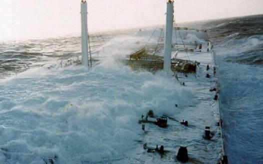
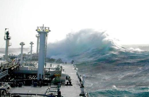
The oceanic route of Drake Passage normally is affected by bad weather, where winds of more than 60 Knots, and waves of 10 to 12 meters height are very common.
A TANKER NAVIGATING DRAKE PASSAGE
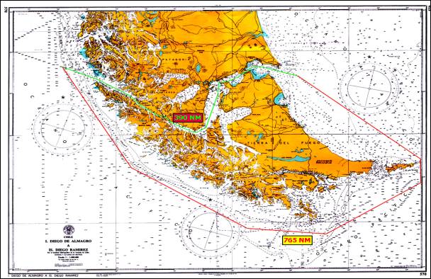
Another point to considerer is that the distance, for vessels sailing from the Western Atlantic Ocean which decide to cross the Drake Passage, passing East of Isla de los Estados, from a point 30 nautical miles East of Punta Dúngenes to a point 30 nautical miles West of Islotes Evangelistas is 765 nautical miles. The distance between these two points sailing throughout Strait of Magellan is 390 nautical miles shorter. In other words, 42 hours less of navigation, at average speeds of 9 knots (considering normal bad weather conditions). (See following graph).
The following picture shows the route and distance from a point SE of Isla de los Estados, for vessels heading to Drake Passage, coming from Europe, Northern Africa or Norteastern Brazil. The sailing distance is 534 nautical miles.
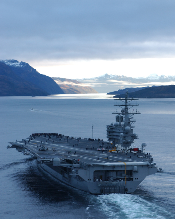
It is interesting to highlight that, in August, 2004, after some previous experiences at Drake Passage; the US Navy planned the transit of Strait of Magellan of the Aircraft Carrier USS "Ronald Reagan". This naval major unit navigated the route assisted by Chilean Pilots, uneventfully, safely and without difficulties. This Aircraft Carrier has 345 meters length overall and 70 meters of breadth.
AIRCRAFT CARRIER USS ¨RONALD REAGAN¨
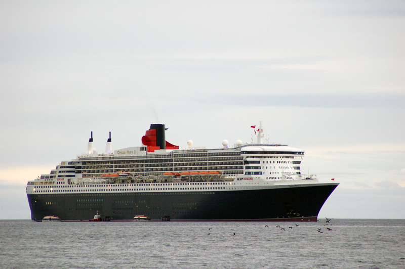
Also, in February 2006, the passengers vessel Queen Mary II, of 345 meters length overall and a breadth of 41 meters sailed the Strait of Magellan with Chilean Pilots onboard, for the first time.
PASSENGERS SHIP "QUEEN MARY II"
2.- STRAIT OF MAGELLAN GENERAL INFORMATION
a.- GEOGRAPHIC POSITION AND LEGAL JURISDICTION:
The Strait of Magellan (Estrecho de Magallanes) is a passage located at the southern tip of South America, among the Chilean Patagonia, Tierra del Fuego Island and a number of islands to the West. It is the most important natural passage between the Pacific and the Atlantic Oceans. The Strait, in it whole length, belongs to the Republic of Chile and it is part of the XII Region of Magallanes and Chilean Antarctica (Magallanes y la Antártica Chilena). It's eastern access is surrounded by Argentinean waters. In accordance with Chile-Argentina international treaties of 1881 and 1984, the access and sailing from and to the eastern mouth is accessible to vessels of all nations, at any time and circumstances.
b.- LENGTH:
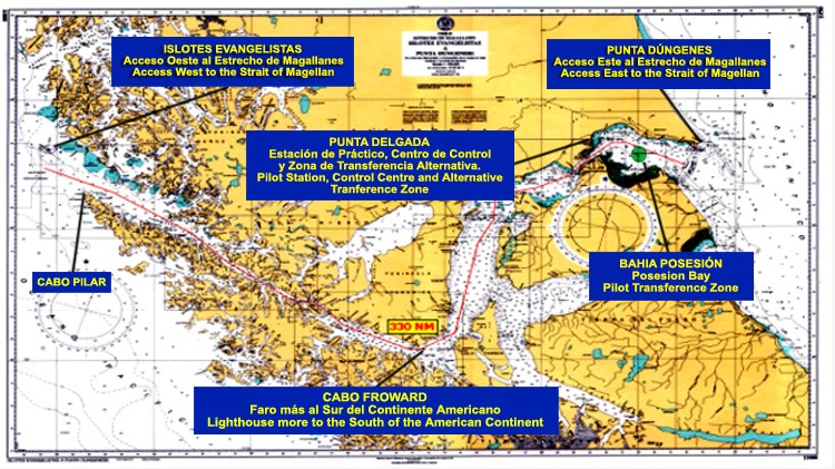
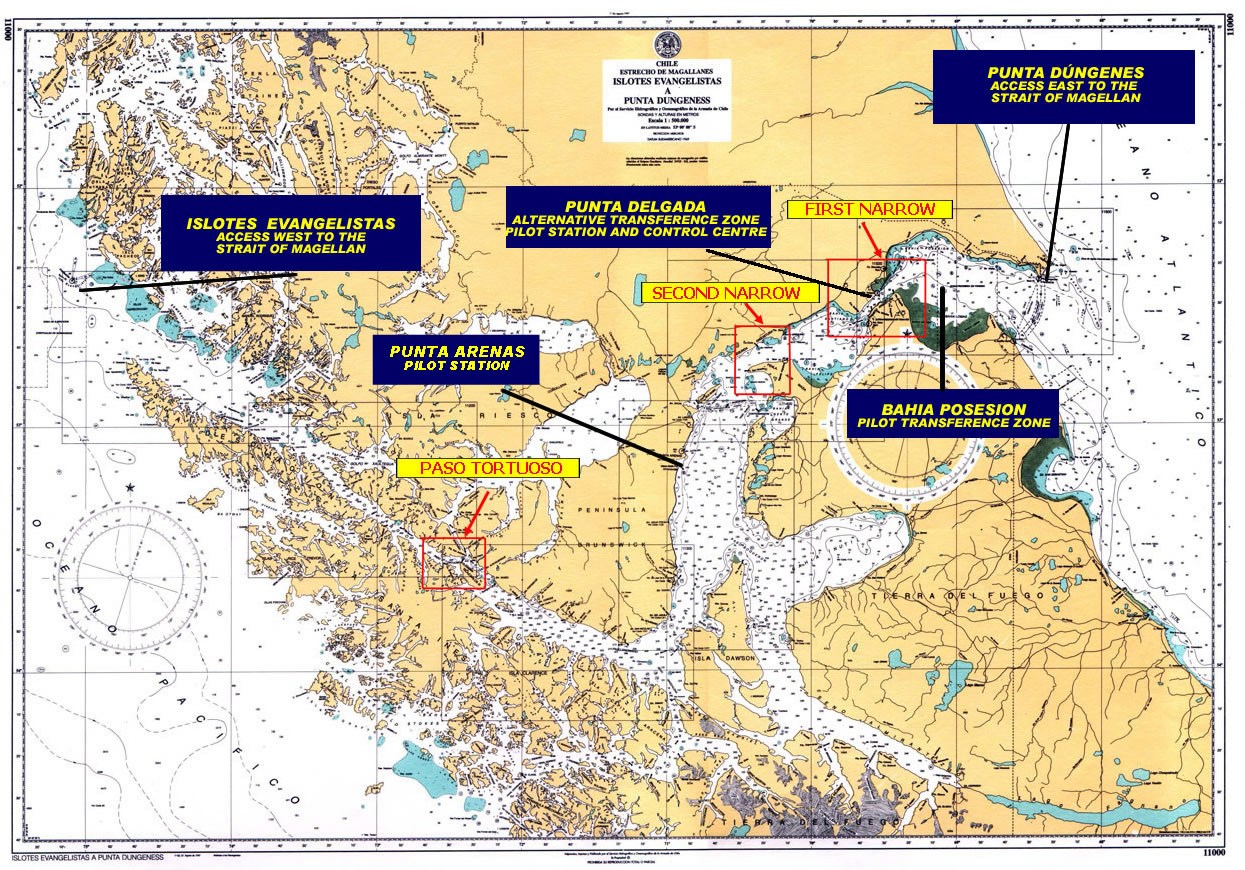
The Strait of Magellan, from the Eastern entrance (Punta Dúngenes) to the Western access (Islotes Evangelistas), has a total length of 330 nautical miles.
c.- CHARACTERISTICS OF THE WESTERN ZONE (FROM CABO PILAR TO CABO FROWARD):
1) Winds and Squalls: Overcast and stormy skies prevail in this zone, either at night or during the day. South Western Pacific storms are received within the Strait, but with weaker winds and without significant waves. Commonly, wind directions are from the NW or SW. The typical form of the wind is that of flurries of extraordinary and short-lasting force, known as squalls, williwaws, storms or showers.
2) Bad meteorological conditions prevailing in the South Pacific area, have made a common practice to most ships, to navigate the Western channels of the Patagonia, considering that they are suitably for a safe transit and properly signaled with beacons, lighthouses and buoys to allow the night navigation. (See the different routes in the Separation C. - "NAVIGATION ROUTES IN CHILEAN STRAITS, CHANNELS AND FIORDS (FROM CHACAO CHANNEL TO CAPE HORN").
3) Tides and currents: The tide range in the Western region of the Strait of Magellan seldom reach more than 2 meters and current intensity is generally insignificant, at least for moderated powered vessels. The only cautionary zone is Paso Tortuoso -in the vicinity of Cabo Crosstide- where currents can go up to 3.5 knots and sometimes a bit stronger near Paso Ingles, because of the crossing of currents from the Strait of Magellan and Canal Jerónimo. In general, the current flows across the prevailing wind directions, that is normally from NW to SE.
4) Oceanic current: The current, near Cabo Pilar, follows the direction of the Strait of Magellan in its mouth; a general SE and S direction, affecting vessels along the Southern coast of this Strait. During calm seas, this current has an intensity of 0.5 and 1.0 knots. The oceanic current increases when it joins the ingoing current.
5) Anchoring: Large anchoring places, in the western region of Strait of Magellan, are very limited. Anchoring sites, indicated in the nautical charts, are recommendations based on previous experiences. To select a proper anchorage it is necessary to consider the size and draught of the vessel, the existing depths and the turning area available. (See Anchoring in the Eastern part, in the letter m. - Emergency anchoring)
6) Prevention: The major risk for night navigation of Strait of Magellan, are the squalls of water or snow that would prevent seeing lights and the coastline. It is required to make proper efforts to keep the vessel on track when sailing Paso Largo, Paso Tortuoso and Paso Ingles, to avoid risky situations.
d.- SAILING DIRECTIONS FOR STRAIT OF MAGELLAN:
| 1).- During crossing Strait of Magellan vessels should strictly meet the International Regulation for Preventing Collisions at Sea, especially all those relating to sound signals. |
| 2).- Vessel shall keep permanent watch on the international safety VHF frequencies, channels 16 and 70. |
| 3).- Report entrance and exit of Strait of Magellan to Maritime Traffic Control Stations at Islotes Evangelistas, Bahía Félix, and Punta Dungeness lighthouses or Pilot Station of Punta Delgada. |
| 4).- Inform to Maritime Authority the vessel's geographic position following CHILREP Procedures, at 08:00 and 20:00 local time. Ships sailing without Pilots should do so every 4 hours.(See Separation A.- number 8.- letter g.- POSITION REPORT (CHILREP)). |
| 5).- Ships with lengths greater than 200 meters will have preference of passage in the narrows. The Maritime Authority will notify when these ships are navigating the Strait. |
e.-AREAS OF INTEREST IN STRAIT OF MAGELLAN:
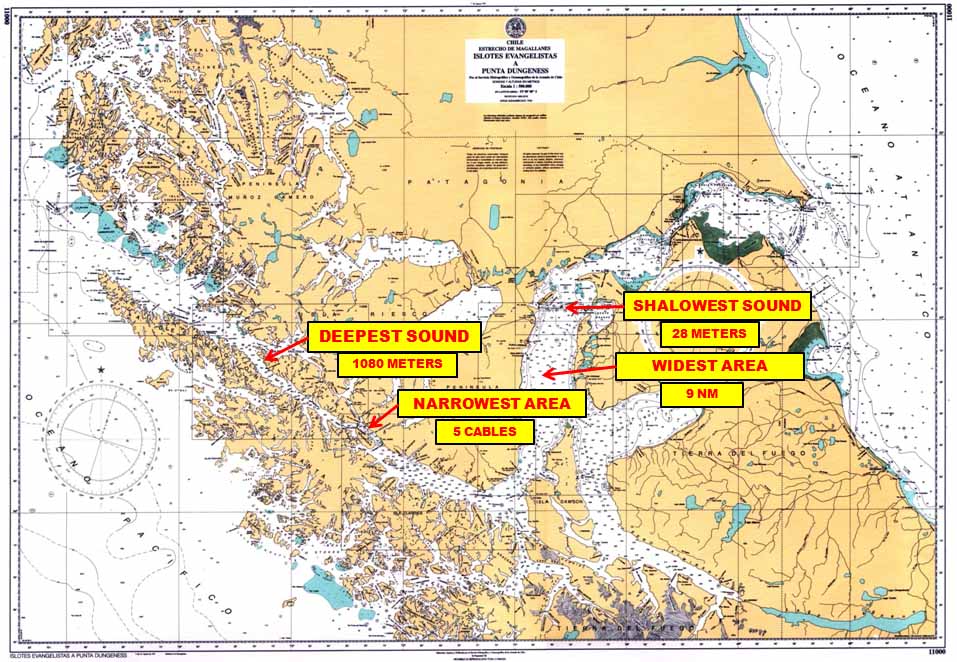
From a navigation point of view this Strait basically has three areas of interest .They are: the First Narrows, the Second Narrows and Paso Tortuoso (See Par. 3,4 and 5).
f.- DEPTHS:
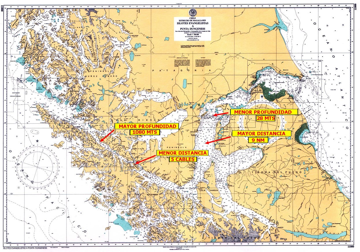
The Navigation track in the Strait is generally deep and wide. The shallowest depth is 28 meters, near Isla Magdalena. The biggest depth, 1.080 meters a beam of Cooper Key lighthouse. The shortest distance to the coast is 5 cables abeam Crosstide Lighthouse and the greatest 9 miles abeam Puerto Porvenir.
The maximum allowed draught to sail the Strait is 70 feet or 21.3 meters.
g.-MARITIME SIGNS:
Aids to navigation are excellent and sufficient to sail at any time, in all its extension. Shallow waters, no less than 4 cables from the track, are well marked. Throughout the passage, from Punta Dungeness to Islotes Evangelistas there are a total of 26 lighthouses and 9 buoys. Navy personnel provide Maritime Traffic Control and assistance at five lighthouses (Evangelistas, Félix, Fairway, Punta Delgada and Dúngenes)
h.- CURRENTS:
Currents show their effects with greater force in the two narrows and Paso Ingles. It is in the First Narrow, where the current is stronger, going from 2 knots in low intensity periods up to 8 knots in sysygys.
i.- TIDE AMPLITUDE:
Tide amplitudes reach their maximum in the first narrow, at Punta Delgada. The maximum observed difference has been up to 8 meters.
j.- LIGHTS HOURS:
In summer these are up to 20 hrs, decreasing in winter time to 6 hrs a day approximately.
k.-ICE OR ICEBERGS:
In the Strait there are no icebergs or other kind of ice formation. It's waters never freeze.
l.- SPEED:
There are no speed restrictions for sailing the Strait. Full sea speed can be use in all it's extension.
m.-EMERGENCY ANCHORAGES:
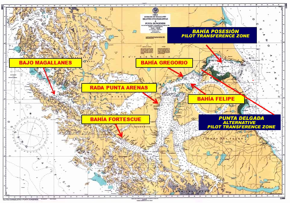
Emergency anchorages for large vessels are almost nonexistent in the Western area, although, in case of extreme need, approaches to Bajo Magallanes - near Felix Lighthouse - can be used for emergencies. At the Eastern part, good anchorage areas exist at the Pilot Transference Zone, in Bahia Posesión, Gregorio and Felipe bays, between the First and Second Narrow, the Port of Punta Arenas and the Port of Fortescue in Paso Ingles vicinity.
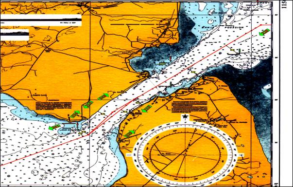
n.- PILOT TRANSFERENCE ZONE:
There is one Transference Zone in Bahía Posesión, close to the Platforms Line, 19 nautical miles from the Pilot Station at Punta Delgada Lighthouse and 22 nautical miles from Dungeness Lighthouse. If bad weather does not allow a safe embarkation at the Transference Zone, there is a waiting area where vessels can anchor in 30 meters of depth. As an alternative, ships can carry on sailing towards or from Punta Delgada, with navigation directions provided by Pilots from the Pilot Station Control Room. To provide this advice, there is radar system with S-57 charts management, integrated AIS and ARPA system (Basic VTS capabilities)
ñ.- SECURITY MESSAGE:
When vessels over 200 meters of length overall, enter the Strait of Magellan, the Maritime Authority transmits a security message, that is relayed by all the manned lighthouses in channel 16 VHF, indicating the priority of pass.
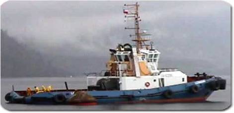
o.- TUGS:
At Punta Arenas, 8 tugboats are available. Their bollard pull is around 65 tons, with engine power from 2,000 to 5,000 hp. They are capable to provide support to any vessel that requires their services.
p.-PILOTING FEES:
1) Ships over 230 meters of LOA, sailing only Strait of Magellan without using any other inner waters channel, will have a 40% discount from "Standard or Base Fee", (See Separation A. - number 6.- Piloting Fees).
2) If navigation includes sailing within any other channel, the discount will not be applied, in accordance with Fee Regulations of DIRECCION GENERAL DEL TERRITORIO MARITIMO (Chilean Maritime Authority), approved by Supreme Decree Number 427 of June 26, 1979. (See www.directemar.cl-Publications(Publicaciones)- Maritime Regulation (Normativa Marítima) - Regulation of Tariffs and Laws (Reglamento de Tarifas y Derechos))
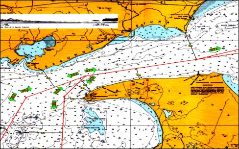
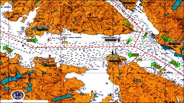
5.- TORTUOSO PASSAGE (PASO TORTUOSO)
The total length of Tortuoso Passage, from Punta San Jerónimo to Cabo Quod, is 6.3 nautical miles, having a minimum useful width of 0.9 nautical miles between Cabo Crosstide and Anson rock.
The Northern coast presents two shoals, properly signalized by buoys (Anson and Crooked); placed 4 cables north of the navigation track.
Cross currents from Jerónimo Channel can be found, which affect transversely ships entering or leaving Paso Inglés.
If desired, large vessels (Big LOA & draught) can wait slack water of Jerónimo Channel in order to sail Paso Tortuoso in quieter and safer conditions. Channel Pilots have experience of crossing Paso Tortuoso on large vessels up to 21,3 of draught, at any time.
SAILING DIRECTIONS FOR TORTUOSO PASSAGE (PASO TORTUOSO)
Given the size increase of modern vessels, some difficulties for quick maneuvers can be expected, making difficult to comply rapidly with the International COLREG, during crossing of Paso Tortuoso. To avoid most dangers and make a safe crossing, the following procedure must be followed:
| 1) Report to Maritime Traffic Control Stations (At Evangelista, Felix, Punta Arenas or Punta Delgada) the ETA to this Passage (Considers ETA abeam Crosstide lighthouse). |
2) Keep permanent attention on channels 16 and 70 VHF. In channel 16 broadcast safety signal, in English and Spanish, one hour before passing Cape "Crosstide" and every 15 minutes until the crossing is finished, reporting the following details:
* SHIP'S NAME
* CROSSING DIRECTION
* CURRENT POSITION
* ETA ABEAM CROSSTIDE LIGHTHOUSE.
|
| 3) Whenever is possible, sail on the Starboard side of the track, without affecting vessel's safety. |
| 4) Priority of pass is given to VLCC or vessels with more than 200 meters of LOA, timely informed by Maritime Authority signals. |
| 5) Keep navigation lights permanently lighted. |